About Site Scan Flight for ArcGIS
Site Scan Flight for ArcGIS makes it easy to collect accurate, high-resolution maps and 3D models using drones. The app is connected to the Site Scan Manager web application and ArcGIS Online, allowing you to import base...
Site Scan Flight for ArcGIS makes it easy to collect accurate, high-resolution maps and 3D models using drones.
The app is connected to the Site Scan Manager web application and ArcGIS Online, allowing you to import base maps, saved flight plans, overlays, and previously captured orthomosaics for precise flight planning. Use your ArcGIS Online credentials to log in to Site Scan for additional security benefits, such as leveraging your organization-specific login method.
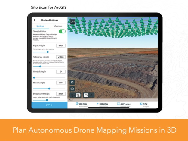
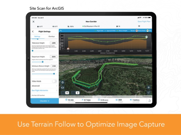
Choose from a variety of flight modes tailored to the type of site being scanned, and the app will automatically define the optimal flight path and allow you to preview it in 2D or 3D. Experienced pilots can use Terrain Follow, which enhances imagery quality by adjusting the drone's height to follow the terrain.
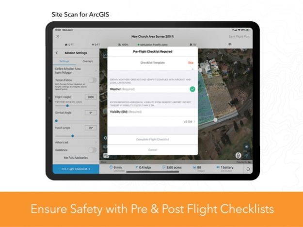
After completing your company preflight checklist, the app automatically conducts aircraft checks and executes the flight. Long flights are automatically split, allowing you to change your drone’s battery and resume where you left off. After completing the flight, wirelessly transfer the images to your iPad and upload them along with your Fleet Management information to Site Scan Manager for processing on the cloud.
Compatibility:
Requires compatible drone: Freefly Astro, DJI P4 Advanced, DJI P4P, DJI P4P V2, DJI P4 RTK, Mavic Pro, Mavic 2 Pro, M200 series, M200 series V2, Inspire 2, M300.
Check the latest documented drone matrix for supported firmware versions.
Requires a paid Site Scan for ArcGIS license.
Jan 18, 2024
Version 4.6.1
- Resolved preflight system check issues for Freefly Astro
- iOS 17 support
- Improved photo estimation
- Airspace link service fix
- Minor bug fixes
Known issues
- Mission recovery issues were found on firmware from DJI M300 RTK v06.01.01.00 and v07.00.01.00 that affect in-app pause action, mission progress, and data capture.
Previous Versions
Here you can find the changelog of Site Scan Flight for ArcGIS since it was posted on our website on 2016-09-29 16:44:31.
The latest version is 4.6.1 and it was updated on 2024-04-22 08:57:05. See below the changes in each version.
Site Scan Flight for ArcGIS version 4.6.1
Updated At: 2024-01-18
Changes: Jan 18, 2024
Version 4.6.1
- Resolved preflight system check issues for Freefly Astro
- iOS 17 support
- Improved photo estimation
- Airspace link service fix
- Minor bug fixes
Known issues
- Mission recovery issues were found on firmware from DJI M300 RTK v06.01.01.00 and v07.00.01.00 that affect in-app pause action, mission progress, and data capture.
Site Scan Flight for ArcGIS version 4.6
Updated At: 2023-06-07
Changes: Jun 7, 2023
Version 4.6
- Flying below takeoff point with terrain follow
- Hot swapping batteries support for DJI M300
- Image capture efficiency enhancements for Freefly Astro
- Improved app performance
- Improved error messaging
Site Scan Flight for ArcGIS version 4.5.2
Updated At: 2023-02-06
Changes: Feb 6, 2023
Version 4.5.2
- DJI M300 image capture interval fix
Known issues:
- M300 missions will capture more images than estimated
- Panorama missions with M300 & P1 35 mm lens require return home to be triggered manually
- After changing lenses on the P1 camera, calibration is required through the DJI Pilot app
Site Scan Flight for ArcGIS version 4.4
Updated At: 2022-06-28
Changes: Jun 28, 2022 Version 4.4
- New option to sign in using ArcGIS credentials
- Define Mission from polyline support for Corridor Scan
- Additional bug fixes
Site Scan Flight for ArcGIS version 4.3.1
Updated At: 2022-04-14
Changes: Apr 14, 2022 Version 4.3.1
- Increased timer for RTK base station signal acquisition.
- Auto detect lenses for P1, X7, X5S cameras on DJI M300
- Fixed LAANC advisories and request of authorization for flight plan area of interest
- Bug fix: Shapefile overlay with Japanese characters returns "Shape overlay error Invalid url."
- Bug fix: PDF overlay with Japanese characters fail to be switched on
- Bug fix: Mission polygon does not update when vertices are dragged to the extents of the map
- Bug fix: Multi battery missions with DJI M300 were not filling waypoints after changing batteries.
- Improved DJI notifications
- Additional bug fixes
Site Scan Flight for ArcGIS version 4.3
Updated At: 2022-02-02
Changes: Feb 2, 2022 Version 4.3
- Freefly Astro support
- DJI M300RTK support with P1 camera
- Flight speed setting. Mission advance settings, you can now adjust the speed of your drone 50% faster or slower than its default speed
- Define mission area from polygon. Use KML and SHP polygons from Site Scan Manager or ArcGIS Online feature layer polygons as Area and Crosshatch survey mission boundaries.
- Post-flight checklist
Site Scan Flight for ArcGIS version 4.2.2
Updated At: 2021-10-11
Changes: Oct 11, 2021 Version 4.2.2
- iOS 15 Support
- Add drone status bar during System Checks, allowing RTK drone pilots to reconnect their RTK base station after a battery change
- Fix XT2 sensor size field of view for survey missions
- Enhance photo import workflow for iOS 15
- Additional bug fixes
Site Scan Flight for ArcGIS version 4.2.1
Updated At: 2021-09-09
Changes: Sep 9, 2021 Version 4.2.1
- Support for India Region
- Enhanced 3D map stability
- Enhanced app stability
- Additional bug fixes
Site Scan Flight for ArcGIS version 4.2
Updated At: 2021-08-04
Changes: Aug 4, 2021 Version 4.2
- Replace the Camera Roll with Files application for iPad photo download and storage
- Enhance reliability of terrain download and improve error messaging
- Enhance time and battery estimates during flight planning
- Enhance the mission location search functionality
- Add new fields to Geospatial Video Logs to enable manual altitude correction for more accurate Full Motion Video in ArcGIS Pro
- Add map north arrow
- Add device compatibility and memory check
- Geofence mission stability enhancements
- Bug fix: skipping photos along flight leg
- Bug fix: updating waypoint status before drone has reached it
- Additional minor bug fixes
- Retire support for H520-G drone and Zenmuse Z30 camera
Site Scan Flight for ArcGIS version 4.1.2
Updated At: 2021-03-22
Changes: Mar 22, 2021 Version 4.1.2
- Fixed issue preventing photos from being uploaded (H520-G and occasional DJI vehicles)
- Various other bug fixes
Disclaimer
Official App Store Link
We do not host Site Scan Flight for ArcGIS on our servers. We did not scan it for viruses, adware, spyware or other type of malware. This app is hosted by Apple and passed their terms and conditions to be listed there. We recommend caution when installing it.
The App Store link for Site Scan Flight for ArcGIS is provided to you by apps112.com without any warranties, representations or guarantees of any kind, so access it at your own risk.
If you have questions regarding this particular app contact the publisher directly. For questions about the functionalities of apps112.com contact us.